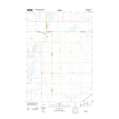
2013 Map of Dundee
USGS Topo · Published 2013About this map
Dundee and Kinbrae anchor this southwestern Minnesota prairie landscape, situated at the convergence of Nobles, Murray, Cottonwood, and Jackson counties. The 2013 topography reveals a region defined by complex glacial hydrology, where the Des Moines River flows through the northeast and Jack Creek meanders across the southern plains. For those researching local heritage, the map identifies specific burial grounds including First Lutheran Cemetery and Saint Marys Cemetery near Dundee, as well as the Kinbrae Cemetery to the south. The area is dotted with significant water bodies and managed wetlands, such as the Wildlife Impoundment and Kinbrae Slough, which highlight the importance of conservation and drainage in this agricultural corridor. Traces of historical infrastructure are visible in the naming of drainage systems like Judicial Ditch Number Twentysix, reflecting the long-term engineering required to cultivate this lake-strewn terrain.
Find a feature on this map
51 named features on this map. Tap any name to fly to it.
Don’t see what you’re looking for? This feature index may not catch every label — zoom into the map to look around manually.
Map Details
Editions of this 2013 Dundee Map
This is the sole edition of this map. No revisions or reprints were ever made.
Other maps of this area

1954 · Fairmont
USGS Topo · 1:250,000

1958 · Fairmont
USGS Topo · 1:250,000

1960 · Brewster
USGS Topo · 1:24,000

1960 · Okabena
USGS Topo · 1:24,000

1960 · Worthington North
USGS Topo · 1:24,000

1970 · Heron Lake NW
USGS Topo · 1:24,000

1970 · Dundee
USGS Topo · 1:24,000
1970 · Heron Lake NE
USGS Topo · 1:24,000

1970 · Fulda
USGS Topo · 1:24,000
1970 · Lime Creek
USGS Topo · 1:24,000