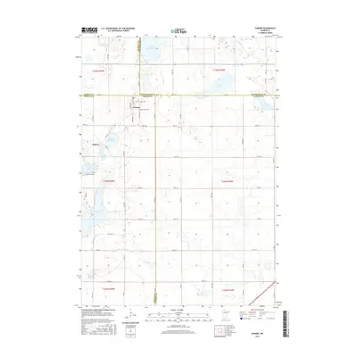
2016 Map of Dundee
USGS Topo · Published 2016About this map
Dundee and Kinbrae sit at the intersection of four southwestern Minnesota counties—Nobles, Cottonwood, Murray, and Jackson—forming a distinct pocket of prairie and wetland geography. The landscape is characterized by a complex network of glacial water bodies, including Clear Lake, Kinbrae Lake, and the winding Des Moines River in the northeast. This 2016 survey documents the agricultural grid and water management features of the region, such as the Wildlife Impoundment and Kinbrae Slough. For genealogists and local historians, the map provides precise locations for three local burial grounds: First Lutheran Cem and Saint Marys Cem near Dundee, and Kinbrae Cem to the south. The distribution of these sites and the grid of township roads like Co HWY 46 and Wempel Ave illustrate the enduring rural settlement patterns of this multi-county borderland.
Find a feature on this map
61 named features on this map. Tap any name to fly to it.
Don’t see what you’re looking for? This feature index may not catch every label — zoom into the map to look around manually.
Map Details
Editions of this 2016 Dundee Map
This is the sole edition of this map. No revisions or reprints were ever made.
Other maps of this area

1954 · Fairmont
USGS Topo · 1:250,000

1958 · Fairmont
USGS Topo · 1:250,000

1960 · Brewster
USGS Topo · 1:24,000

1960 · Okabena
USGS Topo · 1:24,000

1960 · Worthington North
USGS Topo · 1:24,000

1970 · Heron Lake NW
USGS Topo · 1:24,000

1970 · Dundee
USGS Topo · 1:24,000
1970 · Heron Lake NE
USGS Topo · 1:24,000

1970 · Fulda
USGS Topo · 1:24,000
1970 · Lime Creek
USGS Topo · 1:24,000