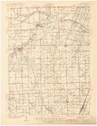
1941 Map of Dundee
USGS Topo · Published 1941About this map
The River Raisin meanders through southeastern Michigan, defining the agricultural landscape of Monroe County just before World War II. Centered on the village of Dundee, this area was a busy junction of early transportation networks, where the Ann Arbor RR, New York Central RR, and Wabash RR intersected. The map documents an incredibly dense network of rural one-room schoolhouses, such as Egypt Sch and Knapp Sch, many of which served small farming hamlets like Rea and Morocco. To the south, the terrain transitions near Ottawa Lake and the distinctive Big Sink, while industry is represented by the Stone Quarry near Saxton. This survey captures the county's township-and-range layout in detail, showing the many family-named drains and runs that managed the local hydrology to support the productive fields surrounding Petersburg and Ida.
Find a feature on this map
133 named features on this map. Tap any name to fly to it.
Don’t see what you’re looking for? This feature index may not catch every label — zoom into the map to look around manually.
Map Details
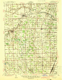
Editions of this 1941 Dundee Map
2 editions found
Other maps of this area

1900 · Maumee Bay
USGS Topo · 1:62,500

1900 · Toledo
USGS Topo · 1:62,500

1902 · Ypsilanti
USGS Topo · 1:62,500

1904 · Ann Arbor
USGS Topo · 1:125,000

1906 · Ypsilanti
USGS Topo · 1:62,500

1906 · Saline
USGS Topo · 1:62,500

1906 · Romulus
USGS Topo · 1:62,500

1908 · Ann Arbor
USGS Topo · 1:125,000

1911 · Swanton
USGS Topo · 1:62,500

1912 · Monroe
USGS Topo · 1:62,500
Featured Places
- Bedford Township, MI
- Lambertville, Bedford Township
- Temperance, Bedford Township
- Raisinville Township, MI
- Ida, Ida Township