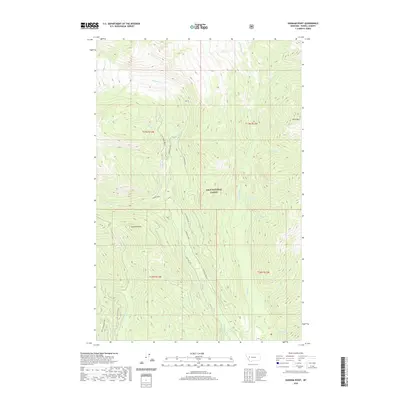
2020 Map of Dunham Point
USGS Topo · Published 2020About this map
Lolo National Forest encompasses the high country of Powell County in this topographic survey, defined by the prominent peak of Fenn Mtn and the landmark Dunham Point. The landscape is characterized by a dense network of drainages and seasonal streams, including the central Dunham Cr and the eastern flow of Monture Cr. The mapping of Forest Development Roads (FDR) such as Upper Spruce and West Stanley illustrates the logistical infrastructure required to manage these public lands in the 21st century. Geographers and local researchers can trace the specific routes of Dunham Creek Rd and Center Ridge, which provide access through the complex terrain of township and range boundaries T17N R13W and T16N R13W. The presence of named water sources like Dry Cottonwood Spr highlights the importance of localized water points in this high-elevation environment.
Find a feature on this map
32 named features on this map. Tap any name to fly to it.
Don’t see what you’re looking for? This feature index may not catch every label — zoom into the map to look around manually.
Map Details
Editions of this 2020 Dunham Point Map
This is the sole edition of this map. No revisions or reprints were ever made.
Other maps of this area

1902 · Ovando
USGS Topo · 1:125,000

1905 · Ovando
USGS Topo · 1:125,000

1955 · Choteau
USGS Topo · 1:250,000

1957 · Choteau
USGS Topo · 1:250,000

1958 · Choteau
USGS Topo · 1:250,000

1962 · Choteau
USGS Topo · 1:250,000
1965 · Woodworth
USGS Topo · 1:24,000

1965 · Morrell Mountain
USGS Topo · 1:24,000

1968 · Spread Mountain
USGS Topo · 1:24,000

1968 · Dunham Point
USGS Topo · 1:24,000