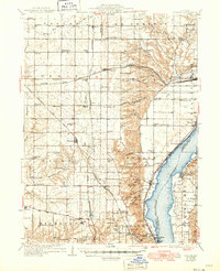
1937 Map of Dunlap
USGS Topo · Published 1949About this map
The Illinois River corridor north of Peoria reveals a landscape defined by sharp bluffs and a dense network of early 20th-century rural infrastructure. This 1930s-era survey, updated just after the war, documents the convergence of three major rail lines—the Chicago and Northwestern, the Atchison Topeka and Santa Fe, and the Chicago Rock Island and Pacific—which shaped the growth of towns like Dunlap and Princeville. Along the western bluffs, the Lucky Strike Mines and Big Hollow Mines indicate the area's industrial activity near the Kickapoo township line.
Find a feature on this map
106 named features on this map. Tap any name to fly to it.
Don’t see what you’re looking for? This feature index may not catch every label — zoom into the map to look around manually.
Map Details
Editions of this 1937 Dunlap Map
3 editions found

Other maps of this area

1893 · Lacon
USGS Topo · 1:62,500

1893 · Metamora
USGS Topo · 1:62,500

1893 · Dunlap
USGS Topo · 1:62,500

1898 · Dunlap
USGS Topo · 1:62,500

1905 · Peoria
USGS Topo · 1:62,500

1927 · Peoria
USGS Topo · 1:62,500

1928 · Mackinaw
USGS Topo · 1:62,500

1930 · Glasford
USGS Topo · 1:62,500

1932 · Mackinaw
USGS Topo · 1:62,500

1932 · Dunlap
USGS Topo · 1:62,500