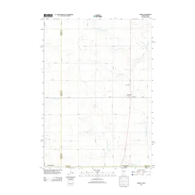
2013 Map of Dunnell
USGS Topo · Published 2013About this map
Dunnell serves as the central hub of this agricultural landscape along the Minnesota-Iowa border. This survey illustrates a highly modified prairie hydrology, where the natural course of the E Fork Des Moines River and Fourmile Cr is supplemented by an extensive network of engineered waterways, including Judicial Ditch Number Eleven and County Ditch Number Fiftythree. These ditches reflect the intensive drainage efforts required to sustain the region's productive farmland.
Find a feature on this map
37 named features on this map. Tap any name to fly to it.
Don’t see what you’re looking for? This feature index may not catch every label — zoom into the map to look around manually.
Map Details
Editions of this 2013 Dunnell Map
This is the sole edition of this map. No revisions or reprints were ever made.
Other maps of this area

1954 · Fairmont
USGS Topo · 1:250,000

1958 · Fairmont
USGS Topo · 1:250,000

1970 · Jackson NW
USGS Topo · 1:24,000

1970 · Ceylon
USGS Topo · 1:24,000

1970 · Jackson
USGS Topo · 1:24,000

1970 · Dunnell
USGS Topo · 1:24,000

1970 · Sherburn
USGS Topo · 1:24,000
1970 · Alpha
USGS Topo · 1:24,000

1972 · Estherville
USGS Topo · 1:24,000
1972 · Superior
USGS Topo · 1:24,000