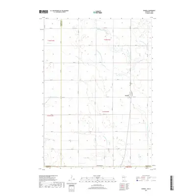
2019 Map of Dunnell
USGS Topo · Published 2019About this map
Dunnell sits at the heart of this agricultural landscape in Martin County, just north of the Iowa border. The terrain is defined by a sophisticated water management system designed to support intensive farming, featuring numerous engineered waterways such as Judicial Ditch Number One Hundred Five and County Ditch Number Fiftythree. These channels augment natural watercourses like Fourmile Cr and the E Fork Des Moines River. Historically-minded researchers will note the Lake Fremont Cem located just north of the town center, a key landmark for local genealogy. The map captures the strictly organized section-line road grid, including Co Hwy 8 and 50th St, which facilitates movement between the scattered farmsteads and the central rail-adjacent settlement of Dunnell.
Find a feature on this map
48 named features on this map. Tap any name to fly to it.
Don’t see what you’re looking for? This feature index may not catch every label — zoom into the map to look around manually.
Map Details
Editions of this 2019 Dunnell Map
This is the sole edition of this map. No revisions or reprints were ever made.
Other maps of this area

1954 · Fairmont
USGS Topo · 1:250,000

1958 · Fairmont
USGS Topo · 1:250,000

1970 · Jackson NW
USGS Topo · 1:24,000

1970 · Ceylon
USGS Topo · 1:24,000

1970 · Jackson
USGS Topo · 1:24,000

1970 · Dunnell
USGS Topo · 1:24,000

1970 · Sherburn
USGS Topo · 1:24,000
1970 · Alpha
USGS Topo · 1:24,000

1972 · Estherville
USGS Topo · 1:24,000
1972 · Superior
USGS Topo · 1:24,000