
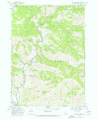
1969 Map of Dunnigan Creek
USGS Topo · Published 1971About this map
Boise National Forest terrain dominates this Boise River watershed survey, where the deep drainage of Mores Creek carves through the landscape to meet the northern reaches of the Lucky Peak Reservoir. The area is defined by a dense network of gulches and creeks, including Grimes Creek, Dunnigan Creek, and Smith Creek, which reflect the region's historical ties to mining and resource extraction. Evidence of early prospecting is visible through labels for a Mine and Prospect located in the southern hills. Transportation through these steep canyons relied on rugged paths like the Adelene Trail and various unnamed jeep trails. Recreational and utility infrastructure is sparsely placed, with a Campground near Thorn Creek and a Pumping Station near Daggett Creek serving the managed forest lands and reservoir waters.
Find a feature on this map
34 named features on this map. Tap any name to fly to it.
Don’t see what you’re looking for? This feature index may not catch every label — zoom into the map to look around manually.
Map Details
Editions of this 1969 Dunnigan Creek Map
2 editions found
Other maps of this area

1892 · Boise
USGS Topo · 1:125,000

1894 · Idaho Basin
USGS Topo · 1:125,000

1897 · Boise
USGS Topo · 1:125,000

1949 · Robie Creek
USGS Topo · 1:24,000

1954 · Boise
USGS Topo · 1:62,500

1955 · Hailey
USGS Topo · 1:250,000

1955 · Boise
USGS Topo · 1:250,000

1957 · Warm Springs Point
USGS Topo · 1:24,000
1957 · Shafer Butte
USGS Topo · 1:24,000

1957 · Idaho City
USGS Topo · 1:24,000