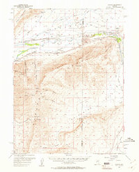
1957 Map of Dunphy
USGS Topo · Published 1961About this map
The Humboldt River corridor dominates this mid-century survey of the high desert, serving as the primary artery for both water and transport across northern Nevada. This landscape is defined by the parallel tracks of the Southern Pacific and Western Pacific railroads, which hug the river's path and support small outposts like Dunphy, Rixies, and Kampos. To the north, the Sheep Creek Range rises above the valley, while the southern reaches are marked by the industrial footprints of the Argenta Mine and the Shelton Mine along the Argenta Rim. The presence of The Geysers in Whirlwind Valley and various isolated springs like White House Spring underscores the critical role of geothermal and water resources in this arid environment. Ranching interests are represented by the T-S Ranch and Dunphy Ranch, located near the winding Blue House Slough, showing how human settlement adapted to the complex drainage patterns of the Great Basin.
Find a feature on this map
49 named features on this map. Tap any name to fly to it.
Don’t see what you’re looking for? This feature index may not catch every label — zoom into the map to look around manually.
Map Details
Editions of this 1957 Dunphy Map
2 editions found
Other maps of this area

1949 · Crescent Valley
USGS Topo · 1:62,500

1949 · Mt. Lewis
USGS Topo · 1:62,500

1950 · Mt. Lewis
USGS Topo · 1:62,500

1950 · Crescent Valley
USGS Topo · 1:62,500

1955 · Winnemucca
USGS Topo · 1:250,000

1957 · Frenchie Creek
USGS Topo · 1:62,500

1957 · Dunphy
USGS Topo · 1:62,500

1957 · Beowawe
USGS Topo · 1:62,500

1957 · Battle Mountain
USGS Topo · 1:62,500

1958 · Winnemucca
USGS Topo · 1:250,000