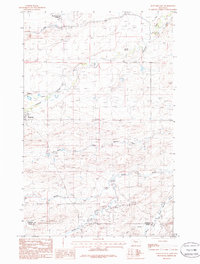
1985 Map of Dupuyer East
USGS Topo · Published 1986About this map
Birch Creek Colony and the small settlement of Dupuyer anchor this 1980s landscape, where the high plains meet the intricate drainage systems of the Rocky Mountain Front. The area is defined by the convergence of several major watercourses, including Birch Creek to the north and the sprawling network of the Dry Fork Marias River. The map reveals a land utilized for both ranching and natural resource extraction, evidenced by the presence of a Gravel Pit and numerous natural water sources like Crocker Springs. The terrain is deeply etched by seasonal water flows, with Jensen Coulee and Bills Coulee cutting through the prairie. Straddling the boundary between Pondera and Teton counties, this survey illustrates how the environment dictates the pattern of human habitation, with roads following the natural contours of the Sheep Creek and Dupuyer Creek valleys.
Find a feature on this map
16 named features on this map. Tap any name to fly to it.
Don’t see what you’re looking for? This feature index may not catch every label — zoom into the map to look around manually.
Map Details
Editions of this 1985 Dupuyer East Map
This is the sole edition of this map. No revisions or reprints were ever made.
Other maps of this area

1914 · Heart Butte
USGS Topo · 1:125,000

1918 · Heart Butte
USGS Topo · 1:125,000

1920 · Dupuyer
USGS Topo · 1:125,000

1934 · Lake Frances
USGS Topo · 1:48,000

1936 · Pendroy
USGS Topo · 1:48,000

1937 · Lake Frances
USGS Topo · 1:62,500

1941 · Pendroy
USGS Topo · 1:62,500

1960 · Cut Bank
USGS Topo · 1:250,000

1963 · Cut Bank
USGS Topo · 1:250,000

1964 · Cut Bank
USGS Topo · 1:250,000
Featured Places
- Pondera Hutterite Colony, MT
- Birch Creek Hutterite Colony, MT
- Pondera County, MT
- Teton County, MT
- United States