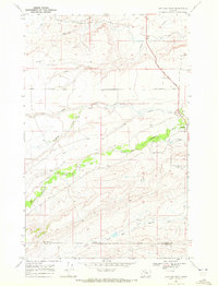
1968 Map of Dupuyer West
USGS Topo · Published 1972About this map
Dupuyer sits at the eastern edge of this landscape where the plains begin to rise toward the Rocky Mountain Front. The settlement is centered near the confluence of Sheep Creek and Dupuyer Creek, reflecting a typical late-sixties Montana ranching community supported by intricate water management systems like Leach Ditch and Burd Dean Ditch. This 1968 field survey records the transition of the high prairie as it meets the northern tributaries of the Marias River system, including the North Fork Dry Fork Marias River.
Find a feature on this map
17 named features on this map. Tap any name to fly to it.
Don’t see what you’re looking for? This feature index may not catch every label — zoom into the map to look around manually.
Map Details
Editions of this 1968 Dupuyer West Map
This is the sole edition of this map. No revisions or reprints were ever made.
Other maps of this area

1914 · Heart Butte
USGS Topo · 1:125,000

1918 · Heart Butte
USGS Topo · 1:125,000

1920 · Dupuyer
USGS Topo · 1:125,000

1934 · Lake Frances
USGS Topo · 1:48,000

1936 · Pendroy
USGS Topo · 1:48,000

1937 · Lake Frances
USGS Topo · 1:62,500

1941 · Pendroy
USGS Topo · 1:62,500

1960 · Cut Bank
USGS Topo · 1:250,000

1963 · Cut Bank
USGS Topo · 1:250,000

1964 · Cut Bank
USGS Topo · 1:250,000