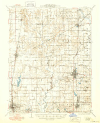
1926 Map of Duquoin
USGS Topo · Published 1950About this map
Duquoin and the surrounding coalfields of Southern Illinois appear here at a time of significant industrial and rural development. The landscape is heavily marked by the region's mining heritage, featuring specific operations such as the Big Ben Mine and Paradise Mine, alongside smaller workings like the Gayle Mine. The settlement pattern follows a dense network of railroads, including the Illinois Central and Missouri Pacific, which fueled the growth of towns like Tamaroa, Sesser, and Waltonville.
Find a feature on this map
96 named features on this map. Tap any name to fly to it.
Don’t see what you’re looking for? This feature index may not catch every label — zoom into the map to look around manually.
Map Details
Editions of this 1926 Duquoin Map
3 editions found
Other maps of this area

1909 · West Frankfort
USGS Topo · 1:62,500

1910 · Herrin
USGS Topo · 1:62,500

1910 · Murphysboro
USGS Topo · 1:62,500

1924 · Pinckneyville
USGS Topo · 1:62,500

1926 · Pinckneyville
USGS Topo · 1:62,500

1926 · Duquoin
USGS Topo · 1:62,500

1931 · Hoyleton
USGS Topo · 1:48,000

1932 · Nashville
USGS Topo · 1:62,500

1933 · Mount Vernon
USGS Topo · 1:48,000

1936 · Nashville
USGS Topo · 1:62,500