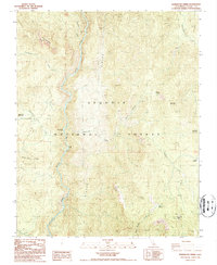
1987 Map of Durrwood Creek
USGS Topo · Published 1987About this map
The Kern River carves a deep valley through the heart of the Sequoia National Forest in this late-twentieth-century study of the southern Sierra Nevada. The terrain is defined by dramatic geological features such as The Needles, Needlerock, and the massive heights of Sherman Peak and Schaeffer Mountain. Human presence is concentrated in seasonal and recreational sites, including Durrwood Camp, Bean Camp, and the Lower Peppermint Campground near Peppermint Creek. A notable Prospect near North Meadow Creek and a Radio Tower on the southern peaks indicate the intersection of traditional resource exploration and modern communication infrastructure within this protected wilderness. The map captures the intricate drainage system feeding into the main river corridor, including Durrwood Creek and Freeman Creek.
Find a feature on this map
26 named features on this map. Tap any name to fly to it.
Don’t see what you’re looking for? This feature index may not catch every label — zoom into the map to look around manually.
Map Details
Editions of this 1987 Durrwood Creek Map
2 editions found
Other maps of this area

1904 · Kaweah
USGS Topo · 1:125,000

1905 · Olancha
USGS Topo · 1:125,000

1905 · Fairview
USGS Topo · 1:24,000

1906 · Kernville
USGS Topo · 1:125,000

1907 · Olancha
USGS Topo · 1:125,000

1908 · Kernville
USGS Topo · 1:125,000

1909 · Kaweah
USGS Topo · 1:125,000

1918 · Fairview
USGS Topo · 1:31,680

1936 · Tobias Peak
USGS Topo · 1:125,000

1937 · Kaweah
USGS Topo · 1:125,000