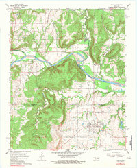
1967 Map of Dustin
USGS Topo · Published 1983About this map
Dustin serves as the primary hub of this 1960s landscape, situated at the intersection of local rail lines and the St Louis San Francisco railroad. The town is flanked by essential community markers such as the Dustin Cem and the Dustin Lake to the east. The terrain is deeply influenced by the energy industry, with the Gregory Oil and Gas Field and West Dustin Field defining much of the subsurface economy. North of the city, the North Canadian River carves a path through the territory, accompanied by an Old Railroad Grade that suggests evolving transportation patterns.
Find a feature on this map
32 named features on this map. Tap any name to fly to it.
Don’t see what you’re looking for? This feature index may not catch every label — zoom into the map to look around manually.
Map Details
Editions of this 1967 Dustin Map
3 editions found
Other maps of this area

1900 · Canadian
USGS Topo · 1:125,000

1900 · Wewoka
USGS Topo · 1:125,000

1946 · Fort Smith
USGS Topo · 1:250,000

1954 · Oklahoma City
USGS Topo · 1:250,000

1957 · Oklahoma City
USGS Topo · 1:250,000

1962 · Henryetta
USGS Topo · 1:24,000

1962 · Henryetta SW
USGS Topo · 1:24,000

1963 · Oklahoma City
USGS Topo · 1:250,000

1965 · Fort Smith
USGS Topo · 1:250,000

1967 · Fort Smith
USGS Topo · 1:250,000