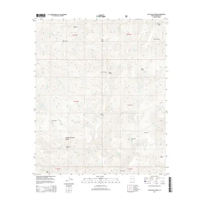
2014 Map of Dutch Blue Creek
USGS Topo · Published 2014About this map
The Blue River drainage carves through the high country of the Apache National Forest in this topographic survey. Centered on the settlement at H U Bar Box, the landscape is defined by its complex network of seasonal creeks and named springs. Notable terrain features like Government Mesa and Paint Rock Prairie rise above deeply incised canyons, including Ladrone Canyon and Rousensock Canyon. The distribution of water resources such as Winter Cabin Spring, Ladison Spring, and N Bull Cr Tank reveals the vital points for ranching and forest management in this corner of Greenlee County. Towards the south, the terrain ascends toward Alder Peak, while the northeast is marked by the broad depression of Bonehead Basin. The map captures a detailed inventory of the riparian and highland features that sustain life in this arid high-elevation environment.
Find a feature on this map
66 named features on this map. Tap any name to fly to it.
Don’t see what you’re looking for? This feature index may not catch every label — zoom into the map to look around manually.
Map Details
Editions of this 2014 Dutch Blue Creek Map
This is the sole edition of this map. No revisions or reprints were ever made.
Other maps of this area

1913 · Morenci
USGS Topo · 1:125,000

1915 · Morenci
USGS Topo · 1:125,000

1922 · Nutrioso
USGS Topo · 1:125,000

1954 · Clifton
USGS Topo · 1:250,000

1957 · Clifton
USGS Topo · 1:250,000

1958 · Clifton
USGS Topo · 1:250,000

1958 · Hannagan Meadow
USGS Topo · 1:62,500

1961 · Blue
USGS Topo · 1:62,500

1962 · Clifton
USGS Topo · 1:250,000
1967 · Alma Mesa
USGS Topo · 1:24,000