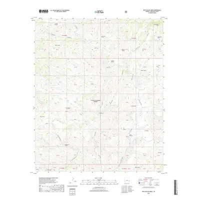
2018 Map of Dutch Blue Creek
USGS Topo · Published 2018About this map
The Apache National Forest in Greenlee County dominates this terrain, where the Blue River carves a central path through a complex network of canyons and mesas. This high-country landscape is defined by its drainage systems, including the Dutch Blue Creek and Little Dutch Blue watersheds. Evidence of historic ranching and back-country access is preserved through numerous named springs such as Bonehead Spring and Mangrum Spring, as well as established backcountry routes like the Thomas Creek Trail and the Hu Bar road. Landmark features like Government Mesa and Alder Peak provide significant topographic relief, while smaller basins such as Salt Basin and Zuni Basin indicate the diverse geological character of the region. The map also identifies specific ranching infrastructure like the H U Bar Box and Benton Tank, marking long-standing human activity within the national forest boundaries.
Find a feature on this map
90 named features on this map. Tap any name to fly to it.
Don’t see what you’re looking for? This feature index may not catch every label — zoom into the map to look around manually.
Map Details
Editions of this 2018 Dutch Blue Creek Map
This is the sole edition of this map. No revisions or reprints were ever made.
Other maps of this area

1913 · Morenci
USGS Topo · 1:125,000

1915 · Morenci
USGS Topo · 1:125,000

1922 · Nutrioso
USGS Topo · 1:125,000

1954 · Clifton
USGS Topo · 1:250,000

1957 · Clifton
USGS Topo · 1:250,000

1958 · Clifton
USGS Topo · 1:250,000

1958 · Hannagan Meadow
USGS Topo · 1:62,500

1961 · Blue
USGS Topo · 1:62,500

1962 · Clifton
USGS Topo · 1:250,000
1967 · Alma Mesa
USGS Topo · 1:24,000