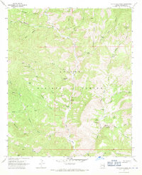
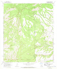
1967 Map of Dutch Blue Creek
USGS Topo · Published 1971About this map
The Blue River carves a deep path through this remote portion of the Apache National Forest, defining a landscape where cattle ranching and wilderness survival intersect. Human presence is marked by isolated outposts like the H U Bar Ranch and scattered shelters such as Winter Cabin and White Rocks Cabin. The terrain is characterized by dramatic elevation changes, from the heights of Government Mesa and Prairie Breaker down to the narrow confines of the H U Bar Box and Little Blue Box. These "boxes" represent steep-walled canyon sections that dictated movement through the backcountry. A network of names like Hannah Hot Spring and Benton Tank reveals the vital importance of water sources in this arid environment, while a web of pack trails and jeep trails provides the only access through the canyons of Dutch Blue Creek and Strayhorse Creek.
Find a feature on this map
45 named features on this map. Tap any name to fly to it.
Don’t see what you’re looking for? This feature index may not catch every label — zoom into the map to look around manually.
Map Details
Editions of this 1967 Dutch Blue Creek Map
4 editions found
Other maps of this area

1913 · Morenci
USGS Topo · 1:125,000

1915 · Morenci
USGS Topo · 1:125,000

1922 · Nutrioso
USGS Topo · 1:125,000

1954 · Clifton
USGS Topo · 1:250,000

1957 · Clifton
USGS Topo · 1:250,000

1958 · Clifton
USGS Topo · 1:250,000

1958 · Hannagan Meadow
USGS Topo · 1:62,500

1961 · Blue
USGS Topo · 1:62,500

1962 · Clifton
USGS Topo · 1:250,000
1967 · Alma Mesa
USGS Topo · 1:24,000