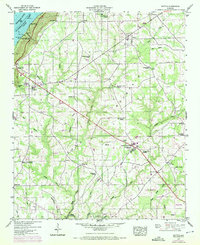
1947 Map of Dutton
USGS Topo · Published 1972About this map
Sand Mountain dominates the central landscape of this Jackson and DeKalb County region, where the Tennessee Valley Authority and U.S. Geological Survey documented a plateau world of rural crossroads and upland farming. The 1970 revisions, marked in purple, illustrate a transition in land use, showing a Drag Strip and an Athletic Field near Section Gap. To the northwest, the map captures the early development of the Lake Shore Drive Cabin Site Area along the shores of Guntersville Lake, where the Tennessee River was impounded to create new recreational and residential patterns.
Find a feature on this map
58 named features on this map. Tap any name to fly to it.
Don’t see what you’re looking for? This feature index may not catch every label — zoom into the map to look around manually.
Map Details
Editions of this 1947 Dutton Map
2 editions found
Other maps of this area

1885 · Gadsden
USGS Topo · 1:125,000

1886 · Stevenson
USGS Topo · 1:125,000

1888 · Gadsden
USGS Topo · 1:125,000

1888 · Scottsboro
USGS Topo · 1:125,000

1892 · Scottsboro
USGS Topo · 1:125,000

1892 · Stevenson
USGS Topo · 1:125,000

1892 · Gadsden
USGS Topo · 1:125,000

1893 · Fort Payne
USGS Topo · 1:125,000

1895 · Stevenson
USGS Topo · 1:125,000

1895 · Gadsden
USGS Topo · 1:125,000