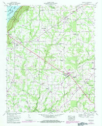
1947 Map of Dutton
USGS Topo · Published 1984About this map
Sand Mountain dominates this portion of Northeast Alabama, where the plateau landscape is defined by agricultural settlements and small rural centers. The 1947 field survey captures the area as it stood before later expansion, showing the proximity of the Guntersville Lake shoreline in the northwest corner near BM 17 TR 606. Cultural history is dense across the quadrangle, evidenced by numerous faith-based landmarks like Old Shady Grove Church and Old Sardis Church, alongside community hubs such as Dutton and Section.
Find a feature on this map
70 named features on this map. Tap any name to fly to it.
Don’t see what you’re looking for? This feature index may not catch every label — zoom into the map to look around manually.
Map Details
Editions of this 1947 Dutton Map
2 editions found
Other maps of this area

1885 · Gadsden
USGS Topo · 1:125,000

1886 · Stevenson
USGS Topo · 1:125,000

1888 · Gadsden
USGS Topo · 1:125,000

1888 · Scottsboro
USGS Topo · 1:125,000

1892 · Scottsboro
USGS Topo · 1:125,000

1892 · Stevenson
USGS Topo · 1:125,000

1892 · Gadsden
USGS Topo · 1:125,000

1893 · Fort Payne
USGS Topo · 1:125,000

1895 · Stevenson
USGS Topo · 1:125,000

1895 · Gadsden
USGS Topo · 1:125,000