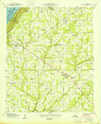
1950 Map of Dutton
USGS Topo · Published 1950About this map
Sand Mountain dominates this mid-century landscape, a high plateau rising above the Tennessee River and the waters of the Guntersville Reservoir. The settlement pattern follows the high ground, with established crossroads like Dutton and Section serving as local hubs. This era shows a community deeply rooted in its local institutions, evidenced by the numerous country churches and schools scattered across the plateau, including Chaney Chapel Church, New Shady Grove Church, and the Patterson School. Along the river’s edge, the Lake Shore Drive Cabin Site Area suggests the beginning of recreational development following the creation of the reservoir. A network of local roads, such as TR 35 and TR 38, connects these upland farms to the Jackson and De Kalb County line, while rugged gaps like Section Gap and Gossett Gap provide passage through the steep terrain.
Find a feature on this map
52 named features on this map. Tap any name to fly to it.
Don’t see what you’re looking for? This feature index may not catch every label — zoom into the map to look around manually.
Map Details
Editions of this 1950 Dutton Map
2 editions found
Other maps of this area

1885 · Gadsden
USGS Topo · 1:125,000

1886 · Stevenson
USGS Topo · 1:125,000

1888 · Gadsden
USGS Topo · 1:125,000

1888 · Scottsboro
USGS Topo · 1:125,000

1892 · Scottsboro
USGS Topo · 1:125,000

1892 · Stevenson
USGS Topo · 1:125,000

1892 · Gadsden
USGS Topo · 1:125,000

1893 · Fort Payne
USGS Topo · 1:125,000

1895 · Stevenson
USGS Topo · 1:125,000

1895 · Gadsden
USGS Topo · 1:125,000