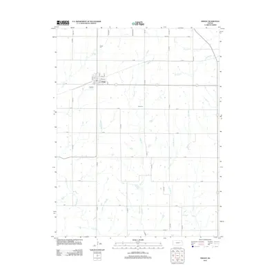
2012 Map of Dwight
USGS Topo · Published 2012About this map
Dwight serves as the primary community hub in this region of Morris County, organized around a traditional street grid including Oak St, Front St, and 1st St. The town's civic infrastructure is anchored by a Po (Post Office) and the nearby Dwight Cem. The surrounding landscape is defined by the headwaters and branches of numerous prairie streams, notably Lairds Cr, Slough Cr, and the winding W Br Mill Cr to the northeast. A precise section-line road network, with names like Wandersee Rd and Tri Co Rd, carves the agricultural terrain into a distinctive checkerboard pattern. Further south, the Swartz Cem sits along D Ave, marking a point of interest for genealogists tracing local families in this quiet corner of the Kansas plains.
Find a feature on this map
41 named features on this map. Tap any name to fly to it.
Don’t see what you’re looking for? This feature index may not catch every label — zoom into the map to look around manually.
Map Details
Editions of this 2012 Dwight Map
This is the sole edition of this map. No revisions or reprints were ever made.
Other maps of this area

1885 · Eskridge
USGS Topo · 1:125,000

1889 · Parkerville
USGS Topo · 1:125,000

1889 · Eskridge
USGS Topo · 1:125,000

1894 · Eskridge
USGS Topo · 1:125,000

1894 · Parkerville
USGS Topo · 1:125,000

1955 · Hutchinson
USGS Topo · 1:250,000

1959 · Hutchinson
USGS Topo · 1:250,000
1971 · Volland
USGS Topo · 1:24,000

1971 · Alta Vista
USGS Topo · 1:24,000
1971 · White City NW
USGS Topo · 1:24,000