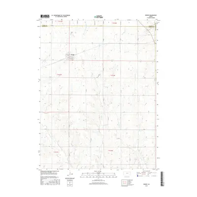
2015 Map of Dwight
USGS Topo · Published 2015About this map
The town of Dwight serves as the central hub of this Morris County landscape, where the street grid of Main St, Oak St, and Cypress St meets the open agricultural plains. The terrain is defined by a dense network of intermittent stream branches, including Slough Cr, Munkers Cr, and the converging forks of Short Cr. These waterways create a series of north-south ridges that dictate the placement of the county road system, such as Quaker Rd and Folk Rd. For those tracing local history, the map identifies key burial sites like Dwight Cem and the more isolated Swartz Cem. The geography reveals a classic Kansas section-line development pattern, where the township and range boundaries of t14s r7e and t14s r8e intersect with natural drainage features like Lairds Cr.
Find a feature on this map
44 named features on this map. Tap any name to fly to it.
Don’t see what you’re looking for? This feature index may not catch every label — zoom into the map to look around manually.
Map Details
Editions of this 2015 Dwight Map
This is the sole edition of this map. No revisions or reprints were ever made.
Other maps of this area

1885 · Eskridge
USGS Topo · 1:125,000

1889 · Parkerville
USGS Topo · 1:125,000

1889 · Eskridge
USGS Topo · 1:125,000

1894 · Eskridge
USGS Topo · 1:125,000

1894 · Parkerville
USGS Topo · 1:125,000

1955 · Hutchinson
USGS Topo · 1:250,000

1959 · Hutchinson
USGS Topo · 1:250,000
1971 · Volland
USGS Topo · 1:24,000

1971 · Alta Vista
USGS Topo · 1:24,000
1971 · White City NW
USGS Topo · 1:24,000