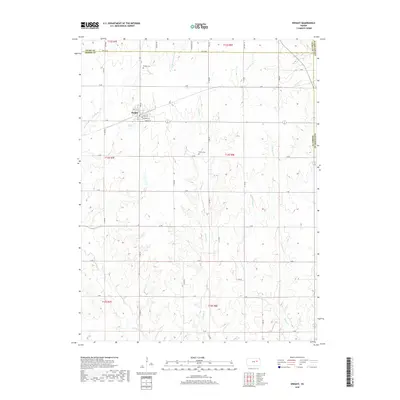
2018 Map of Dwight
USGS Topo · Published 2018About this map
The town of Dwight sits at the intersection of Morris, Geary, and Wabaunsee counties, serving as a focal point for this rural landscape in the Flint Hills region. Detailed street-level data for the community includes Main St, Oak St, and Cypress St, reflecting its established grid. Beyond the settlement, the map documents a terrain defined by the complex drainage of the Kansas River watershed, with numerous tributaries such as Lairds Cr and Slough Cr carving through the prairie. Genealogists and local historians will find the location of the Dwight Cem north of town and the more isolated Swartz Cem to the southeast, providing valuable markers of the area's early families and pioneer heritage. The road network, including the boundary-defining Tri Co Rd, illustrates the intersection of local transport and political geography in this part of Kansas.
Find a feature on this map
48 named features on this map. Tap any name to fly to it.
Don’t see what you’re looking for? This feature index may not catch every label — zoom into the map to look around manually.
Map Details
Editions of this 2018 Dwight Map
This is the sole edition of this map. No revisions or reprints were ever made.
Other maps of this area

1885 · Eskridge
USGS Topo · 1:125,000

1889 · Parkerville
USGS Topo · 1:125,000

1889 · Eskridge
USGS Topo · 1:125,000

1894 · Eskridge
USGS Topo · 1:125,000

1894 · Parkerville
USGS Topo · 1:125,000

1955 · Hutchinson
USGS Topo · 1:250,000

1959 · Hutchinson
USGS Topo · 1:250,000
1971 · Volland
USGS Topo · 1:24,000

1971 · Alta Vista
USGS Topo · 1:24,000
1971 · White City NW
USGS Topo · 1:24,000