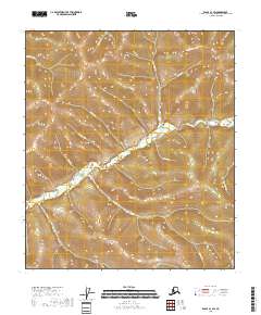
2018 Map of Eagle A-1 SW
USGS Topo · Published 2018About this map
The Top of the World Highway traverses the northern ridge lines of this high-elevation landscape in the Southeast Fairbanks Census Area. This remote stretch of terrain is defined by a dense network of drainages that feed into the Walker Fork, a primary watercourse winding through the central portion of the map. Numerous smaller tributaries such as Ophelia Cr, Robinson Cr, and Dakota Cr carve through the steep topography, illustrating the complex watershed patterns of the region. The map detail reflects the modern wilderness character of this borderland area, where human infrastructure is limited to the single high-altitude roadway. Below the highway, the land falls away into deep valleys shaped by Twelvemile Cr and Juneau Cr, providing a clear record of the area's natural hydrology and geological contours as they existed in the early twenty-first century.
Find a feature on this map
15 named features on this map. Tap any name to fly to it.
Don’t see what you’re looking for? This feature index may not catch every label — zoom into the map to look around manually.
Map Details
Editions of this 2018 Eagle A-1 SW Map
This is the sole edition of this map. No revisions or reprints were ever made.
Other maps of this area

1899 · Fortymile
USGS Topo · 1:250,000

1949 · Tanacross
USGS Topo · 1:250,000

1950 · Tanacross
USGS Topo · 1:250,000

1951 · Eagle
USGS Topo · 1:250,000

1956 · Tanacross D-2
USGS Topo · 1:63,360

1956 · Tanacross D-1
USGS Topo · 1:63,360

1956 · Eagle A-1
USGS Topo · 1:63,360

1956 · Eagle A-2
USGS Topo · 1:63,360

1956 · Tanacross
USGS Topo · 1:250,000

1957 · Eagle
USGS Topo · 1:250,000