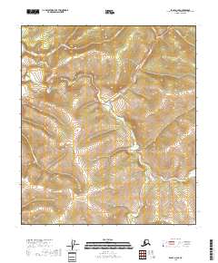
2018 Map of Eagle A-2 SE
USGS Topo · Published 2018About this map
Taylor Highway winds through the high interior of the Southeast Fairbanks Census Area, tracing the ridgelines and valley flanks of this Alaskan landscape. This 2018 survey reveals a drainage network defined by the Walker Fork, which collects various named tributaries including Liberty Cr and Wade Cr. The terrain is characterized by sharp elevation changes, where small watercourses like Napoleon Cr and Wall Street Cr have carved distinct paths through the hills.
Find a feature on this map
12 named features on this map. Tap any name to fly to it.
Don’t see what you’re looking for? This feature index may not catch every label — zoom into the map to look around manually.
Map Details
Editions of this 2018 Eagle A-2 SE Map
This is the sole edition of this map. No revisions or reprints were ever made.
Other maps of this area

1899 · Fortymile
USGS Topo · 1:250,000

1949 · Tanacross
USGS Topo · 1:250,000

1950 · Tanacross
USGS Topo · 1:250,000

1951 · Eagle
USGS Topo · 1:250,000

1956 · Tanacross D-2
USGS Topo · 1:63,360

1956 · Tanacross D-1
USGS Topo · 1:63,360

1956 · Eagle A-1
USGS Topo · 1:63,360

1956 · Eagle A-2
USGS Topo · 1:63,360

1956 · Tanacross
USGS Topo · 1:250,000

1957 · Eagle
USGS Topo · 1:250,000