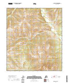
2018 Map of Eagle A-4 SW
USGS Topo · Published 2018About this map
Kechumstuk Mtn rises above a network of drainages in the Southeast Fairbanks area, defining a landscape shaped by seasonal waterflow and high-altitude terrain. The topography is dominated by the winding course of Kechumstuk Cr, which receives tributaries like Telegraph Cr as it moves through the northeastern reaches of the survey. The absence of roads or permanent settlements in this 2018 study emphasizes the remote nature of this part of the interior, where land use is primarily defined by the Public Land Survey System boundaries such as t27n r13e. Smaller waterways including Cedar Cr and Copper Cr carve through the western slopes, illustrating the complex hydrological patterns that feed into the larger regional basins.
Find a feature on this map
10 named features on this map. Tap any name to fly to it.
Don’t see what you’re looking for? This feature index may not catch every label — zoom into the map to look around manually.
Map Details
Editions of this 2018 Eagle A-4 SW Map
This is the sole edition of this map. No revisions or reprints were ever made.
Other maps of this area

1949 · Tanacross
USGS Topo · 1:250,000

1950 · Tanacross
USGS Topo · 1:250,000

1951 · Eagle
USGS Topo · 1:250,000

1956 · Tanacross D-4
USGS Topo · 1:63,360

1956 · Eagle A-5
USGS Topo · 1:63,360

1956 · Eagle A-4
USGS Topo · 1:63,360
1956 · Tanacross D-5
USGS Topo · 1:63,360

1956 · Tanacross
USGS Topo · 1:250,000

1957 · Eagle
USGS Topo · 1:250,000

1964 · Tanacross
USGS Topo · 1:250,000