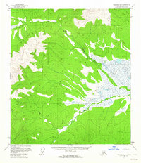
1956 Map of Tanacross D-5
USGS Topo · Published 1964About this map
Mosquito Fork winds through a landscape of expansive wetlands and high ridges in this mid-century survey of the Alaska interior. The map focuses on the hydrologic network of the region, where the broad, marshy valley of the fork meets the drainage of Wolf Creek. A singular evidence of human presence appears near the center of the sheet at a Cabin (Ruins), suggesting an isolated outpost or trapping site that had already fallen into disrepair by the mid-1950s. The terrain is defined by steep relief rising from the water-saturated lowlands, illustrating the difficult geography that limited settlement in this portion of the Tanacross D-5 quadrangle. The lack of roads or established trails on the map emphasizes the wilderness character of the area during this era of aerial photogrammetric mapping.
Find a feature on this map
3 named features on this map. Tap any name to fly to it.
Don’t see what you’re looking for? This feature index may not catch every label — zoom into the map to look around manually.
Map Details
Editions of this 1956 Tanacross D-5 Map
This is the sole edition of this map. No revisions or reprints were ever made.
Other maps of this area

1949 · Tanacross
USGS Topo · 1:250,000

1950 · Tanacross
USGS Topo · 1:250,000

1951 · Eagle
USGS Topo · 1:250,000

1954 · Tanacross C-6
USGS Topo · 1:63,360

1954 · Tanacross D-6
USGS Topo · 1:63,360
1955 · Tanacross C-6
USGS Topo · 1:63,360
1955 · Tanacross D-6
USGS Topo · 1:63,360

1956 · Tanacross D-4
USGS Topo · 1:63,360

1956 · Eagle A-5
USGS Topo · 1:63,360
1956 · Tanacross C-5
USGS Topo · 1:63,360