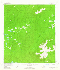
1956 Map of Tanacross C-5
USGS Topo · Published 1964About this map
Lake Mansfield sits at the southern edge of this interior landscape, which was mapped via aerial photography in the mid-1950s. The terrain is dominated by the prominent rise of Sixtymile Butte, a massive landform that anchors the eastern portion of the sheet. Winding through the central valley, Mansfield Creek drains the surrounding uplands, creating a network of smaller tributaries and marshy lowlands. At the time of this survey, the area remained largely inaccessible by road, marked primarily by survey control points such as VABM Mansfield 2765. The map captures a wilderness in transition, where the United States Department of the Interior was documenting remote topography and water systems before any significant modern infrastructure reached this part of the Alaska territory.
Find a feature on this map
4 named features on this map. Tap any name to fly to it.
Don’t see what you’re looking for? This feature index may not catch every label — zoom into the map to look around manually.
Map Details
Editions of this 1956 Tanacross C-5 Map
2 editions found
Other maps of this area

1948 · Tanacross B-5
USGS Topo · 1:63,360

1949 · Tanacross
USGS Topo · 1:250,000

1949 · Tanacross B-4
USGS Topo · 1:63,360

1949 · Tanacross B-6
USGS Topo · 1:63,360

1950 · Tanacross
USGS Topo · 1:250,000

1951 · Tanacross B-6
USGS Topo · 1:63,360

1951 · Tanacross B-4
USGS Topo · 1:63,360

1952 · Tanacross B-5
USGS Topo · 1:63,360

1954 · Tanacross C-6
USGS Topo · 1:63,360

1954 · Tanacross D-6
USGS Topo · 1:63,360