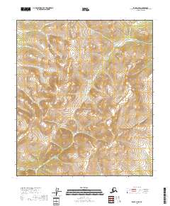
2018 Map of Eagle A-5 SE
USGS Topo · Published 2018About this map
Kechumstuk Cr and Caribou Cr define the high drainage basins of this interior Alaskan landscape, where the terrain is dominated by steep-sided ridges and narrow valleys. This area of the Southeast Fairbanks Census Area is a complex network of seasonal and perennial waterways, including the uniquely named Silas Pup and the more conventional My Cr and Our Cr. The land is subdivided by the Public Land Survey System, with boundaries such as t27n r11e and t26n r12e marking the map's grid. The absence of roads or established settlements emphasizes the remote nature of this portion of the Eagle quadrangle, where the primary geographical markers are the winding paths of Iron Cr and Cedar Cr.
Find a feature on this map
12 named features on this map. Tap any name to fly to it.
Don’t see what you’re looking for? This feature index may not catch every label — zoom into the map to look around manually.
Map Details
Editions of this 2018 Eagle A-5 SE Map
This is the sole edition of this map. No revisions or reprints were ever made.
Other maps of this area

1949 · Tanacross
USGS Topo · 1:250,000

1950 · Tanacross
USGS Topo · 1:250,000

1951 · Eagle
USGS Topo · 1:250,000

1956 · Tanacross D-4
USGS Topo · 1:63,360

1956 · Eagle A-5
USGS Topo · 1:63,360

1956 · Eagle A-4
USGS Topo · 1:63,360
1956 · Tanacross D-5
USGS Topo · 1:63,360

1956 · Tanacross
USGS Topo · 1:250,000

1957 · Eagle
USGS Topo · 1:250,000

1964 · Tanacross
USGS Topo · 1:250,000