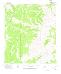
1956 Map of Eagle A-5
USGS Topo · Published 1980About this map
Fortymile River and its Middle Fork carve through the high elevations of the Yukon-Tanana Uplands in this mid-1950s survey. The landscape is defined by an intricate network of drainages, including the aptly named Gold Bottom Creek and Kechumstuk Creek, which flow through a region deeply tied to early Alaskan prospecting and resource exploration. The presence of a Tractor Trail and a lone Cabin near Caribou Creek highlights the sparse, utilitarian nature of human activity in this era, likely supporting mining or seasonal hunting camps.
Find a feature on this map
17 named features on this map. Tap any name to fly to it.
Don’t see what you’re looking for? This feature index may not catch every label — zoom into the map to look around manually.
Map Details
Editions of this 1956 Eagle A-5 Map
2 editions found
Other maps of this area

1949 · Tanacross
USGS Topo · 1:250,000

1950 · Tanacross
USGS Topo · 1:250,000

1951 · Eagle
USGS Topo · 1:250,000

1954 · Tanacross D-6
USGS Topo · 1:63,360
1955 · Tanacross D-6
USGS Topo · 1:63,360

1956 · Tanacross D-4
USGS Topo · 1:63,360

1956 · Eagle A-5
USGS Topo · 1:63,360

1956 · Eagle B-5
USGS Topo · 1:63,360

1956 · Eagle B-4
USGS Topo · 1:63,360

1956 · Eagle A-4
USGS Topo · 1:63,360