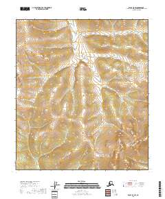
2018 Map of Eagle A-5 SW
USGS Topo · Published 2018About this map
Molly Cr carves a central path through this section of the Southeast Fairbanks Census Area, serving as the primary drainage for the surrounding highlands. The landscape is defined by its watercourses, including Our Cr and Milk Cr in the northern reaches, and the headwaters of Iron Cr to the east. This 2018 survey reveals a terrain largely dictated by its natural topography and the Public Land Survey System divisions of t27n r10e, t27n r11e, t26n r10e, and t26n r11e. The absence of named settlements or roads underscores the wilderness character of this region during the early 21st century, where land use is primarily defined by township and range boundaries rather than human infrastructure.
Find a feature on this map
10 named features on this map. Tap any name to fly to it.
Don’t see what you’re looking for? This feature index may not catch every label — zoom into the map to look around manually.
Map Details
Editions of this 2018 Eagle A-5 SW Map
This is the sole edition of this map. No revisions or reprints were ever made.
Other maps of this area

1949 · Tanacross
USGS Topo · 1:250,000

1950 · Tanacross
USGS Topo · 1:250,000

1951 · Eagle
USGS Topo · 1:250,000

1954 · Tanacross D-6
USGS Topo · 1:63,360
1955 · Tanacross D-6
USGS Topo · 1:63,360

1956 · Eagle A-5
USGS Topo · 1:63,360
1956 · Tanacross D-5
USGS Topo · 1:63,360

1956 · Eagle A-6
USGS Topo · 1:63,360

1956 · Tanacross
USGS Topo · 1:250,000

1957 · Eagle
USGS Topo · 1:250,000