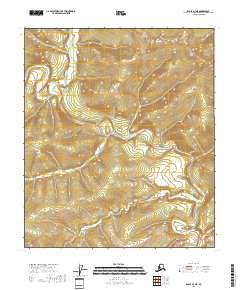
2018 Map of Eagle B-3 NE
USGS Topo · Published 2018About this map
The Middle Fork Fortymile River and the North Fork Fortymile River wind through this remote corner of Southeast Fairbanks. The geography is defined by a significant hydrological junction where smaller tributaries like Bullion Cr and Hutchinson Cr feed into the larger river systems. A standout topographic anomaly known as The Kink appears in the southeast, where the river's path takes a sharp, distinctive bend. This area, historically significant for its role in the early Alaska gold rushes, remains largely unsettled on this modern survey, showing a landscape still dominated by its original drainage patterns and township lines like t5s r29e. The map serves as a clear record of the primitive waterway corridors that once guided prospectors through the Fortymile district.
Find a feature on this map
9 named features on this map. Tap any name to fly to it.
Don’t see what you’re looking for? This feature index may not catch every label — zoom into the map to look around manually.
Map Details
Editions of this 2018 Eagle B-3 NE Map
This is the sole edition of this map. No revisions or reprints were ever made.
Other maps of this area

1899 · Fortymile
USGS Topo · 1:250,000

1951 · Eagle
USGS Topo · 1:250,000

1956 · Eagle C-2
USGS Topo · 1:63,360

1956 · Eagle B-2
USGS Topo · 1:63,360

1956 · Eagle B-3
USGS Topo · 1:63,360

1956 · Eagle C-3
USGS Topo · 1:63,360

1957 · Eagle
USGS Topo · 1:250,000
2018 · Eagle B-3 SW
USGS Topo · 1:25,000
2018 · Eagle C-3 SE
USGS Topo · 1:25,000
2018 · Eagle B-3 SE
USGS Topo · 1:25,000