1983 Map of Eagle Point
USGS Topo · Published 1983About this map
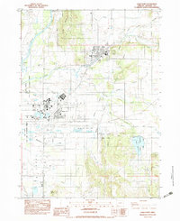
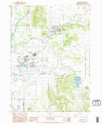
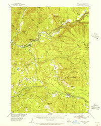
Eagle Point and White City anchor this Jackson County landscape during the early 1980s, revealing an intricate network of water management and industrial infrastructure. The Rogue River flows through the northwest corner, marked by the Rattlesnake Rapids, while the Agate Reservoir and various water systems like the Medford Aqueduct, Canal, and Int Ditch illustrate the complex irrigation and resource needs of the Agate Desert region.
Find a feature on this map
37 named features on this map. Tap any name to fly to it.
Don’t see what you’re looking for? This feature index may not catch every label — zoom into the map to look around manually.
Map Details
Editions of this 1983 Eagle Point Map
2 editions found
Other maps of this area

1891 · Ashland
USGS Topo · 1:250,000

1893 · Ashland
USGS Topo · 1:250,000

1897 · Ashland
USGS Topo · 1:250,000

1938 · Medford
USGS Topo · 1:125,000
1943 · Trail
USGS Topo · 1:62,500
1954 · Medford
USGS Topo · 1:62,500
1954 · Butte Falls
USGS Topo · 1:62,500
1954 · Lakecreek
USGS Topo · 1:62,500

1955 · Medford
USGS Topo · 1:250,000

1957 · Medford
USGS Topo · 1:250,000