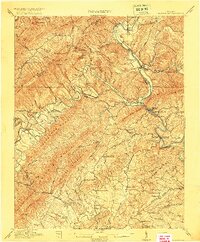
1915 Map of Eagle Rock
USGS Topo · Published 1915About this map
Rich Patch Mine and the remnants of the iron industry anchor this early 20th-century landscape in the Alleghany and Botetourt borderlands. The map documents an era of industrial transition, clearly marking several historic ironworks as Roaring Run Furnace (Ruins), Grace Furnace (Ruins), and Salisbury Furnace (Ruins). These sites, alongside settlements like Lignite and Oriskany, trace the extraction economy that once thrived between the ridges of Paterson Mountain and Price Mountain.
Find a feature on this map
112 named features on this map. Tap any name to fly to it.
Don’t see what you’re looking for? This feature index may not catch every label — zoom into the map to look around manually.
Map Details
Editions of this 1915 Eagle Rock Map
3 editions found
Other maps of this area

1887 · Lewisburg
USGS Topo · 1:125,000

1890 · Roanoke
USGS Topo · 1:125,000

1890 · Christiansburg
USGS Topo · 1:125,000

1891 · Roanoke
USGS Topo · 1:125,000

1891 · Lewisburg
USGS Topo · 1:125,000

1894 · Natural Bridge
USGS Topo · 1:125,000

1894 · Natural Bridge
USGS Topo · 1:62,500

1907 · Natural Bridge Special
USGS Topo · 1:62,500

1913 · Eagle Rock
USGS Topo · 1:48,000

1915 · Eagle Rock
USGS Topo · 1:62,500