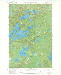
1956 Map of Eagles Nest
USGS Topo · Published 1971About this map
Bear Head Lake State Park and the surrounding timberlands of the Superior National Forest dominate this mid-century look at St. Louis County. The landscape is defined by a dense network of glacial lakes, including the four distinct bodies of the Eagles Nest Lake chain and the expansive Armstrong Lake. While much of the territory is dedicated to conservation and recreation, evidenced by a campground and picnic area on the shores of Bear Head Lake, industrial infrastructure is present in the north. The Duluth Missabe and Iron Range railroad skirts the northern edge, serving the small settlements of Robinson and McComber. The map provides detailed bathymetry for several lakes, compiled from Minnesota Department of Conservation charts, offering a rare look at the underwater topography of these northwoods waters before modern shoreline developments altered the area.
Find a feature on this map
49 named features on this map. Tap any name to fly to it.
Don’t see what you’re looking for? This feature index may not catch every label — zoom into the map to look around manually.
Map Details
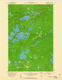
Editions of this 1956 Eagles Nest Map
5 editions found

Other maps of this area

1933 · Ely
USGS Topo · 1:62,500

1939 · Ely
USGS Topo · 1:62,500

1949 · Isaac Lake
USGS Topo · 1:24,000

1949 · Embarrass
USGS Topo · 1:24,000

1950 · Isaac Lake
USGS Topo · 1:24,000

1950 · Embarrass
USGS Topo · 1:24,000

1951 · Babbitt
USGS Topo · 1:24,000

1954 · Two Harbors
USGS Topo · 1:250,000

1954 · Hibbing
USGS Topo · 1:250,000

1956 · Chad Lake
USGS Topo · 1:24,000