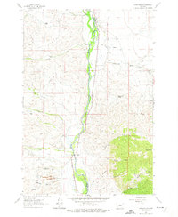
1961 Map of Earls Gulch
USGS Topo · Published 1974About this map
The Beaverhead River and the Big Hole River converge in a wide valley floor, marking the boundary between Madison Co and Beaverhead Co. This 1961 field-checked survey reveals an era of ranching and early industry along the western slopes of McCartney Mountain. The landscape is etched with irrigation efforts like the Pendergast Ditch and Gallagher Ditch, which support several family operations including the Kalsta Ranch and McCullough Ranch. Resource extraction is evident south of Brownes Gulch, where a Tungsten Mill and several mines are located near Sassman Gulch. The Union Pacific railroad corridor parallels the water, providing a vital transport link through this ranching territory. The presence of a Strip Mine and various mines suggests a shift from agriculture to mineral exploration in the mid-20th century.
Find a feature on this map
42 named features on this map. Tap any name to fly to it.
Don’t see what you’re looking for? This feature index may not catch every label — zoom into the map to look around manually.
Map Details
Editions of this 1961 Earls Gulch Map
5 editions found
Other maps of this area

1893 · Dillon
USGS Topo · 1:250,000

1952 · Twin Adams Mountain
USGS Topo · 1:24,000

1955 · Dillon
USGS Topo · 1:250,000

1957 · Dillon
USGS Topo · 1:250,000

1958 · Dillon
USGS Topo · 1:250,000

1958 · Vipond Park
USGS Topo · 1:62,500

1960 · Glen
USGS Topo · 1:24,000

1960 · Block Mountain
USGS Topo · 1:24,000

1961 · Melrose
USGS Topo · 1:24,000

1961 · Earls Gulch
USGS Topo · 1:24,000