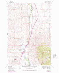
1961 Map of Earls Gulch
USGS Topo · Published 1989About this map
The Big Hole River serves as the primary artery for this high-country landscape, marking the boundary between Beaverhead and Madison counties. This late-twentieth-century study of the drainage basin shows a rugged agricultural economy defined by widely spaced ranching operations such as Breeden Ranch and Mc Cullough Ranch. The presence of several family-named outfits, including the Kambich Ranch and Schuetz Ranch, suggests a long-standing settlement pattern tied to water rights and alluvial grazing land.
Find a feature on this map
36 named features on this map. Tap any name to fly to it.
Don’t see what you’re looking for? This feature index may not catch every label — zoom into the map to look around manually.
Map Details
Editions of this 1961 Earls Gulch Map
5 editions found
Other maps of this area

1893 · Dillon
USGS Topo · 1:250,000

1952 · Twin Adams Mountain
USGS Topo · 1:24,000

1955 · Dillon
USGS Topo · 1:250,000

1957 · Dillon
USGS Topo · 1:250,000

1958 · Dillon
USGS Topo · 1:250,000

1958 · Vipond Park
USGS Topo · 1:62,500

1960 · Glen
USGS Topo · 1:24,000

1960 · Block Mountain
USGS Topo · 1:24,000

1961 · Melrose
USGS Topo · 1:24,000

1961 · Earls Gulch
USGS Topo · 1:24,000