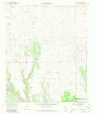
1968 Map of East Afton
USGS Topo · Published 1981About this map
The small farming community of East Afton and the neighboring settlement of Croton anchor this West Texas landscape during a period of late-century revision. The terrain is defined by the headwaters of the South Wichita River and the winding course of Little Croton Creek, which carve through the plains. The map reflects a rural economy dependent on water management, evidenced by features like Duncan Tank and Wichita Tank, alongside several gravel pits that hint at local road-building and infrastructure maintenance. A Landing Strip in the northeast quadrant suggests the increasing role of private aviation in managing these expansive ranching and agricultural lands. Originally surveyed in 1968, this edition incorporates 1979 revisions that document subtle changes in field patterns and local landmarks like Washout Creek and the Riley area.
Find a feature on this map
12 named features on this map. Tap any name to fly to it.
Don’t see what you’re looking for? This feature index may not catch every label — zoom into the map to look around manually.
Map Details
Editions of this 1968 East Afton Map
2 editions found
Other maps of this area

1954 · Lubbock
USGS Topo · 1:250,000

1967 · Dickens North
USGS Topo · 1:24,000

1967 · Dickens South
USGS Topo · 1:24,000

1968 · East Afton
USGS Topo · 1:24,000

1968 · Pitchfork Ranch
USGS Topo · 1:24,000

1968 · Dumont
USGS Topo · 1:24,000

1968 · Croton Camp
USGS Topo · 1:24,000

1968 · East Afton NE
USGS Topo · 1:24,000

1968 · Sanders Hollow
USGS Topo · 1:24,000

1968 · Afton
USGS Topo · 1:24,000