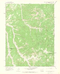
1964 Map of East Evacuation Creek
USGS Topo · Published 1968About this map
Oil Spring Mountain dominates the northeastern corner of this western Colorado landscape, which sits along the border of Rio Blanco and Garfield counties. During the mid-1960s, the area remained largely a wilderness defined by a complex network of drainages including Missouri Creek and the bifurcated branches of East Evacuation Creek and West Evacuation Creek. Human activity is primarily evidenced by scattered resource exploration and seasonal land use, seen in the several Drill Hole markers and a lonely Corral located near the center of the sheet. Traces of earlier occupation or temporary shelters appear as Ruins south of the Chain Canyon confluence. The topography is deeply incised by numerous named draws such as Timber Canyon, Calf Canyon, and Bear Canyon, connected by a series of primitive jeep trails that follow the winding creek beds and ridgelines.
Find a feature on this map
26 named features on this map. Tap any name to fly to it.
Don’t see what you’re looking for? This feature index may not catch every label — zoom into the map to look around manually.
Map Details
Editions of this 1964 East Evacuation Creek Map
2 editions found
Other maps of this area

1885 · East Tavaputs
USGS Topo · 1:250,000

1956 · Grand Junction
USGS Topo · 1:250,000

1959 · Grand Junction
USGS Topo · 1:250,000

1960 · Grand Junction
USGS Topo · 1:250,000

1962 · Grand Junction
USGS Topo · 1:250,000

1964 · Grand Junction
USGS Topo · 1:250,000

1964 · Texas Creek
USGS Topo · 1:24,000

1964 · Douglas Pass
USGS Topo · 1:24,000

1964 · East Evacuation Creek
USGS Topo · 1:24,000
1964 · Texas Mountain
USGS Topo · 1:24,000