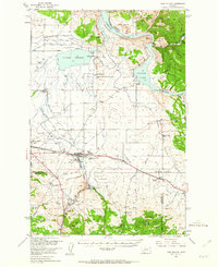
1950 Map of East Helena
USGS Topo · Published 1963About this map
The Missouri River and its upper reservoirs define this Montana landscape as it appeared in the mid-20th century. At the center of the local economy and infrastructure, East Helena sits at the junction of the Great Northern and Northern Pacific railroads. The area south of the river is a network of named gulches and creeks, including Mitchell Gulch and McClellan Creek, which supported early industrial activity at sites like the Economy Mine and Gregory Mine.
Find a feature on this map
51 named features on this map. Tap any name to fly to it.
Don’t see what you’re looking for? This feature index may not catch every label — zoom into the map to look around manually.
Map Details
Editions of this 1950 East Helena Map
4 editions found

Other maps of this area

1886 · Fort Logan
USGS Topo · 1:250,000

1889 · Helena
USGS Topo · 1:250,000

1893 · Helena
USGS Topo · 1:250,000

1899 · Boulder
USGS Topo · 1:125,000

1899 · Helena
USGS Topo · 1:62,500

1899 · Helena
USGS Topo · 1:250,000

1903 · Helena
USGS Topo · 1:250,000

1947 · Butte
USGS Topo · 1:250,000

1948 · White Sulphur Springs
USGS Topo · 1:250,000

1950 · Jefferson City
USGS Topo · 1:62,500