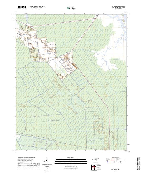
2022 Map of East Lake SE
USGS Topo · Published 2022About this map
Roanoke Marsh and the surrounding wetland expanse of eastern North Carolina define this coastal environment as it appeared in the early 21st century. The map reveals an intricate network of local roads and tracks, such as Miltail Rd and Sawyer Lake Rd, which provide access through the dense vegetation of the Long Stretch. The presence of Borrow Pit Rd and numerous tracks named for local wildlife—including Canvasback Rd, Widgeon Rd, and Pollock Rd—points to a landscape managed for drainage and perhaps habitat or conservation. To the east, the transition from marsh to open water is marked by Callaghan Creek and Spencer Creek, showing the delicate interface between the mainland and the sound. This survey captures a highly specialized coastal geography where human access is limited to a distinct grid of utility and service roads.
Find a feature on this map
41 named features on this map. Tap any name to fly to it.
Don’t see what you’re looking for? This feature index may not catch every label — zoom into the map to look around manually.
Map Details
Editions of this 2022 East Lake SE Map
This is the sole edition of this map. No revisions or reprints were ever made.
Other maps of this area

1943 · Roanoke Island
USGS Topo · 1:125,000

1953 · Wanchese
USGS Topo · 1:24,000

1953 · Engelhard NW
USGS Topo · 1:24,000

1953 · Buffalo City
USGS Topo · 1:24,000

1953 · Stumpy Point
USGS Topo · 1:24,000

1953 · Manteo
USGS Topo · 1:24,000

1953 · East Lake SE
USGS Topo · 1:24,000

1953 · Manns Harbor
USGS Topo · 1:24,000
1953 · East Lake
USGS Topo · 1:24,000

1953 · Engelhard NE
USGS Topo · 1:24,000