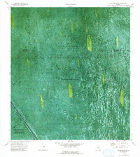
1973 Map of East of Deem City
USGS Topo · Published 1993About this map
The Everglades dominated this portion of the Florida landscape in the early 1970s, defined largely by water management and conservation infrastructure. This orthophotomap, derived from 1971 aerial photography, documents the vast marshlands where the North New River Canal cuts a straight path along the southwestern corner, flanked by Levee 38 W. Much of the area is partitioned into specific zones like the Wildlife Management Area and Conservation Area No 2A, where water is periodically impounded. The terrain is crisscrossed by several Airboat Trails, reflecting the primary method of traversing these wetlands. A small Gaging Sta and various camps are the only signs of human infrastructure in a region otherwise dedicated to hydrological control and habitat preservation near the Palm Beach and Broward County line.
Find a feature on this map
9 named features on this map. Tap any name to fly to it.
Don’t see what you’re looking for? This feature index may not catch every label — zoom into the map to look around manually.
Map Details
Editions of this 1973 East of Deem City Map
2 editions found
Other maps of this area

1956 · West Palm Beach
USGS Topo · 1:250,000

1957 · West Palm Beach
USGS Topo · 1:250,000

1958 · West Palm Beach
USGS Topo · 1:250,000

1963 · Andytown
USGS Topo · 1:24,000

1963 · Fort Lauderdale 2 SE
USGS Topo · 1:24,000
1963 · Cooper City NE
USGS Topo · 1:24,000

1973 · Everglades 4 NE
USGS Topo · 1:24,000
1973 · Fort Lauderdale 2 NE
USGS Topo · 1:24,000

1973 · Fort Lauderdale 2 SW
USGS Topo · 1:24,000

1974 · Everglades 1 SE
USGS Topo · 1:24,000