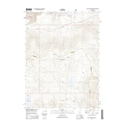
2014 Map of East Park Reservoir
USGS Topo · Published 2014About this map
Ashley National Forest dominates this high-altitude landscape along the border of Daggett and Uintah Counties. The map centers on the East Park Reservoir, a critical water management feature fed by Little Brush Cr, which flows through a series of mountain meadows including Brush Park, Lake Park, and Big Park. To the west, the Oaks Park Reservoir sits near the headwaters of Potters Cr, illustrating the complex network of mountain drainage and storage essential to this region. The terrain is marked by distinct basins and flats such as Eagle Basin and Dyer Park, while State Hwy 44 provides the primary transit route through the northern section, winding past Greens Lakes and crossing several forks of Eagle Creek.
Find a feature on this map
43 named features on this map. Tap any name to fly to it.
Don’t see what you’re looking for? This feature index may not catch every label — zoom into the map to look around manually.
Map Details
Editions of this 2014 East Park Reservoir Map
This is the sole edition of this map. No revisions or reprints were ever made.
Other maps of this area
1885 · Ashley
USGS Topo · 1:250,000
1906 · Marsh Peak
USGS Topo · 1:125,000
1908 · Marsh Peak
USGS Topo · 1:125,000
1950 · Burnt Cabin Gorge
USGS Topo · 1:24,000
1950 · Dyer Mountain
USGS Topo · 1:24,000
1952 · Dutch John Mtn
USGS Topo · 1:24,000
1952 · Flaming Gorge
USGS Topo · 1:24,000

1954 · Vernal
USGS Topo · 1:250,000

1958 · Vernal
USGS Topo · 1:250,000

1960 · Vernal
USGS Topo · 1:250,000