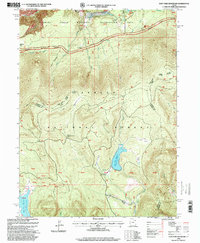
1996 Map of East Park Reservoir
USGS Topo · Published 1999About this map
Ashley National Forest dominates this high-altitude landscape of the Uinta Mountains, where water management and recreation infrastructure meet at the Daggett and Uintah County line. The map highlights significant engineering in the high country, specifically the East Park Reservoir and Oaks Park Reservoir, both crucial for water storage and regulation in this arid region. The presence of the Red Canyon Lodge and multiple campgrounds near Greens Lakes signals the area's development for tourism within the Flaming Gorge National Recreation Area. These forest lands are crisscrossed by historic routes including the Uinta Highline Trail and the Flaming Gorge Vernal Trail, which follow the natural contours of the drainage systems. The detailed mapping of various parks like Lonesome Park and Dyer Park illustrates the diverse meadow ecosystems found among the timbered slopes, used for both grazing and recreation.
Find a feature on this map
49 named features on this map. Tap any name to fly to it.
Don’t see what you’re looking for? This feature index may not catch every label — zoom into the map to look around manually.
Map Details
Editions of this 1996 East Park Reservoir Map
This is the sole edition of this map. No revisions or reprints were ever made.
Other maps of this area

1885 · Ashley
USGS Topo · 1:250,000

1906 · Marsh Peak
USGS Topo · 1:125,000

1908 · Marsh Peak
USGS Topo · 1:125,000

1950 · Burnt Cabin Gorge
USGS Topo · 1:24,000

1950 · Dyer Mountain
USGS Topo · 1:24,000

1952 · Dutch John Mtn
USGS Topo · 1:24,000

1952 · Flaming Gorge
USGS Topo · 1:24,000

1954 · Vernal
USGS Topo · 1:250,000

1958 · Vernal
USGS Topo · 1:250,000

1960 · Vernal
USGS Topo · 1:250,000