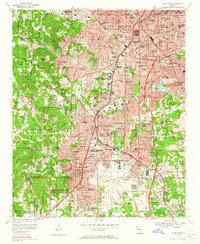
1954 Map of East Point
USGS Topo · Published 1965About this map
Military Reservation Fort Mc Pherson anchors the central landscape of this mid-century survey, a period when the southern reach of Atlanta was rapidly expanding. This transition from suburban to urban density is evident in the dense street grids of West End and East Point, while the southeastern corner is dominated by the sprawling footprint of the Atlanta Municipal Airport. The map is a significant record for researchers of higher education, detailing several historically Black colleges such as Morehouse College, Spelman College, and Clark College, alongside specialized institutions like the Gammon Theological Seminary.
Find a feature on this map
117 named features on this map. Tap any name to fly to it.
Don’t see what you’re looking for? This feature index may not catch every label — zoom into the map to look around manually.
Map Details
Editions of this 1954 East Point Map
5 editions found

Other maps of this area

1888 · Atlanta
USGS Topo · 1:125,000

1890 · Atlanta
USGS Topo · 1:125,000

1891 · Marietta
USGS Topo · 1:125,000

1892 · Atlanta
USGS Topo · 1:125,000

1895 · Atlanta
USGS Topo · 1:125,000

1895 · Marietta
USGS Topo · 1:125,000

1897 · Marietta
USGS Topo · 1:125,000

1901 · Marietta
USGS Topo · 1:125,000

1953 · Atlanta
USGS Topo · 1:250,000

1954 · Conley
USGS Topo · 1:24,000