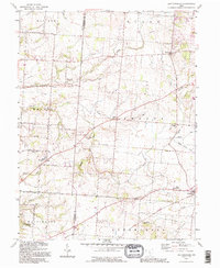
1992 Map of East Ringgold
USGS Topo · Published 1995About this map
Little Walnut Creek and its numerous tributaries, including Toby Creek and Turkey Run, define the rolling agricultural landscape across the Pickaway and Fairfield county line. This 1990s record of the region captures a network of small settlements and rural landmarks, many of which are anchored by long-standing community institutions. Sites like East Union Ch and East Union Cem along the South Bloomfield-Royalton Road highlight the area's deep-rooted local history. To the south, the terrain descends toward A W Marion State Park, while the eastern portion of the map is dominated by the village of Amanda and the neighboring community of New Strasburg. The map illustrates a grid of country roads, such as Bells Station-Fairfield Road, connecting isolated farmsteads and small hubs like Cedar Hill and East Ringgold.
Find a feature on this map
41 named features on this map. Tap any name to fly to it.
Don’t see what you’re looking for? This feature index may not catch every label — zoom into the map to look around manually.
Map Details
Editions of this 1992 East Ringgold Map
This is the sole edition of this map. No revisions or reprints were ever made.
Other maps of this area

1907 · Lancaster
USGS Topo · 1:62,500

1907 · Thurston
USGS Topo · 1:62,500

1909 · Lancaster
USGS Topo · 1:62,500

1909 · Thurston
USGS Topo · 1:62,500

1914 · Circleville
USGS Topo · 1:62,500

1925 · East Columbus
USGS Topo · 1:62,500

1943 · Circleville
USGS Topo · 1:62,500

1943 · East Columbus
USGS Topo · 1:62,500

1947 · Columbus
USGS Topo · 1:250,000
1955 · Lockbourne
USGS Topo · 1:24,000