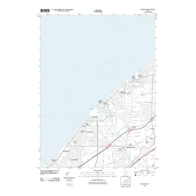
2010 Map of Eastlake
USGS Topo · Published 2010About this map
The Chagrin River flows into Lake Erie at Chagrin Harbor, anchoring a densely developed suburban shoreline where numerous residential enclaves and beaches define the landscape. Cities like Eastlake, Willoughby, and Willowick dominate the southern half of the sheet, while smaller incorporated villages such as Timberlake and Lakeline occupy the waterfront. Transport and infrastructure are prominent, with the Lost Nation Airport situated in the northeast and the Airborne Memorial Bridge spanning the river near the Willoughby Post Office. Genealogists will note the Lost Nation Road Cemetery and Willoughby Village Cemetery, while the presence of Lakeshore Marina and West Pier Light highlights the area's nautical character. The map captures a mature 21st-century residential grid, punctuated by recreation sites like Camp Herrick and the Johnny Cake Ridge Golf Course.
Find a feature on this map
57 named features on this map. Tap any name to fly to it.
Don’t see what you’re looking for? This feature index may not catch every label — zoom into the map to look around manually.
Map Details
Editions of this 2010 Eastlake Map
This is the sole edition of this map. No revisions or reprints were ever made.
Other maps of this area

1901 · Euclid
USGS Topo · 1:62,500

1903 · Euclid
USGS Topo · 1:62,500

1905 · Mentor
USGS Topo · 1:62,500

1907 · Mentor
USGS Topo · 1:62,500

1950 · Cleveland
USGS Topo · 1:250,000

1953 · East Cleveland
USGS Topo · 1:24,000
1953 · Mayfield Heights
USGS Topo · 1:24,000

1953 · Chesterland
USGS Topo · 1:24,000

1953 · Mentor
USGS Topo · 1:24,000
1953 · Eastlake
USGS Topo · 1:24,000