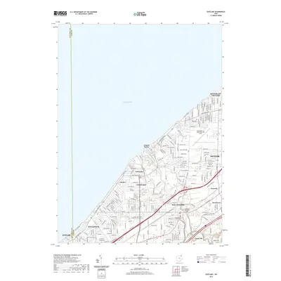
2019 Map of Eastlake
USGS Topo · Published 2019About this map
Lake Erie defines the northern coastline of this Lake County region, where residential expansion and aviation infrastructure meet the water. The suburban character of Eastlake, Willoughby, and Mentor is captured in detail, showing a landscape defined by organized residential plats and major thoroughfares like Lakeland Blvd and Mentor Ave. The industrial and transportation identity of the area is anchored by the Willoughby Lost Nation Municipal Airport and the complex crossings of the Chagrin River, including the Airborne Memorial Bridge. Pockets of local history remain visible through sites such as the Lost Nation Road Cem and Willoughby Village Cem, while the Bryant and Stratton College-Eastlake Campus points to the area's modern educational facilities. Small lakeshore communities like Lakeline and Timberlake provide a contrast to the denser inland developments of Euclid and Willowick.
Find a feature on this map
32 named features on this map. Tap any name to fly to it.
Don’t see what you’re looking for? This feature index may not catch every label — zoom into the map to look around manually.
Map Details
Editions of this 2019 Eastlake Map
This is the sole edition of this map. No revisions or reprints were ever made.
Other maps of this area

1901 · Euclid
USGS Topo · 1:62,500

1903 · Euclid
USGS Topo · 1:62,500

1905 · Mentor
USGS Topo · 1:62,500

1907 · Mentor
USGS Topo · 1:62,500

1950 · Cleveland
USGS Topo · 1:250,000

1953 · East Cleveland
USGS Topo · 1:24,000
1953 · Mayfield Heights
USGS Topo · 1:24,000

1953 · Chesterland
USGS Topo · 1:24,000

1953 · Mentor
USGS Topo · 1:24,000
1953 · Eastlake
USGS Topo · 1:24,000