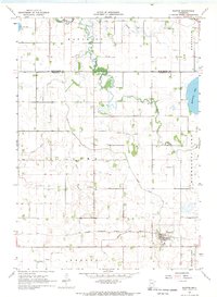
1967 Map of Easton
USGS Topo · Published 1969About this map
Easton serves as the primary settlement in this late 1960s study of the southern Minnesota prairie, where the Chicago Milwaukee St Paul and Pacific railroad cuts a straight line across the landscape. The region is defined by its extensive water management system, featuring an intricate network of engineered waterways such as Judicial Ditch No 9 and County Ditch No 73 that drain the fertile agricultural lands surrounding Lura Lake and Minnesota Lake.
Find a feature on this map
18 named features on this map. Tap any name to fly to it.
Don’t see what you’re looking for? This feature index may not catch every label — zoom into the map to look around manually.
Map Details
Editions of this 1967 Easton Map
This is the sole edition of this map. No revisions or reprints were ever made.
Other maps of this area

1954 · Fairmont
USGS Topo · 1:250,000

1954 · Mason City
USGS Topo · 1:250,000

1955 · Bricelyn
USGS Topo · 1:62,500

1957 · Mason City
USGS Topo · 1:250,000

1958 · Mason City
USGS Topo · 1:250,000

1958 · Fairmont
USGS Topo · 1:250,000

1967 · Minnesota Lake
USGS Topo · 1:24,000
1967 · Mapleton
USGS Topo · 1:24,000
1967 · Delavan
USGS Topo · 1:24,000
1967 · Mapleton NE
USGS Topo · 1:24,000