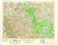
1953 Map of Eau Claire
USGS Topo · Published 1975About this map
The Chippewa River and Eau Claire River converge at the heart of this regional study, illustrating the mid-century industrial and agricultural landscape of West-Central Wisconsin. This era shows the developed rail networks of the Chicago and North Western and the Soo Line serving established timber and dairy hubs like Chippewa Falls and Marshfield. Beyond the urban centers, the terrain is defined by a series of distinct geological formations, including Hay Creek Mound, Wildcat Mound, and Castle Rock, which rise above the surrounding plains.
Find a feature on this map
142 named features on this map. Tap any name to fly to it.
Don’t see what you’re looking for? This feature index may not catch every label — zoom into the map to look around manually.
Map Details
Editions of this 1953 Eau Claire Map
4 editions found

Other maps of this area

1902 · Marathon
USGS Topo · 1:125,000

1909 · Sparta
USGS Topo · 1:62,500

1916 · Tomah
USGS Topo · 1:62,500

1919 · Kendall
USGS Topo · 1:62,500

1921 · Mauston
USGS Topo · 1:62,500

1921 · Kendall
USGS Topo · 1:62,500

1924 · Black River Falls
USGS Topo · 1:62,500

1926 · Black River Falls
USGS Topo · 1:62,500

1926 · North Bend
USGS Topo · 1:62,500

1926 · Whitehall
USGS Topo · 1:62,500